Black Point Geology
The bedrock in the area of Black Point is the Narragansett Pier/Westerly Granite which is Permian in age (275 million years old).
The granite formed in a magma chamber that was 15-20 km (9-12 miles) below the surface. The minerals in the granite include potassium feldspar, white plagioclase, smoky quartz, garnet, muscovite, biotite and magnetite.
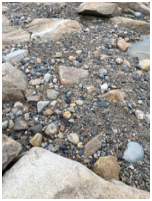
You can see a variety of textures (grain sizes) in the minerals. The texture was controlled by the volatile content in the magma. Water-rich magmas have rapid crystal growth and large crystals whereas drier magmas have fine-grain crystallization. You can come up with a chronological sequence by looking at the textures. In some areas of Black Point medium-grained granite is cut by a younger coarse-grained pegmatite (see Figure 1 below).
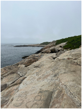
Figure 1 (Photo by Crystal Gryszkiewicz)
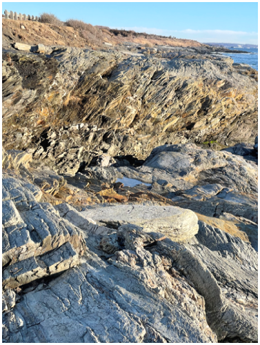
There cracks in the rocks (see Figure 2) that are either joints (a fracture where there is no relative displacement of the rocks on either side) or faults (where there is relative displacement along the fracture). The joints are due to unroofing. When the material above the magma chamber (the Rhode Island Formation) was removed, the rock expanded and cracked. Some joint blocks have been progressively worn into rounded boulders by wave action in storms.
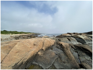
Figure 2 (Photo by Jacob Schlapfer)
You can see evidence of differential weathering at the bedrock surface (see Figure 1). Salt wedging occurs in coastal zones where seawater seeps into cracks then evaporates. The salt crystals grow within the cracks and apply pressure on the surrounding rock.
Another type of physical weathering that occurs in the area is frost wedging. Water in cracks freezes and expands. The expanding ice imparts pressure against the rock and wedges open the crack.
At several times in the Pleistocene Epoch (2.54 million to 11,500 years before the present) all of New England and most of north-central United States and Canada was covered with great sheets of glacial ice. The maximum glacial range occurred approximately 26,000 years before the present during the Late Wisconsinan. At that time the glacial ice extended just past Block Island. This recent glacial event erased most of the evidence for previous Pleistocene glaciations.
The ice sheets in New England consisted of several lobes that were locally controlled by bedrock topography. Black Point is very close to the interlobate zone between the Hudson-Champlain lobe to the west (over Connecticut and western Rhode Island) and the Narragansett Bay-Buzzards Bay lobe to the east (over Narragansett Bay and eastern Massachusetts). Grooves and striae gouged by the glacier in the bedrock at nearby Newton Avenue have a bearing of South 18o West confirming that the Narragansett Bay-Buzzards Bay lobe covered the area. The Point Judith moraine (till with thin layers and lenses of sand, gravel and silt) was deposited at the west side of the Narragansett Bay-Buzzards Bay ice lobe. Other moraines in the area include the Beacon Hill/Corn Neck end moraines in Block Island and the Charlestown end moraine. The Charlestown end moraine is a linear belt that extends from Watch Hill in the southwest to approximately 2 km (1.2 miles) west of Point Judith. It is 2 km (1.2 miles) wide and rises abruptly above the outwash plain abutting its southern boundary.
Large boulders were carried by the ice sheets and deposited when the ice sheets melted. Some of these glacial erratics can be found in the Black Point area (see Figure 3).
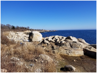
Figure 3 (Photo by Phil Dusky)
-Information from O. Don Hermes, Teresa Smith and Beth Laliberte, URI Geosciences Department.
Black Point is an easy place to begin to learn about geology because it is fairly simple. We have bedrock, Narragansett Pier Granite which was formed from molten rock deep underground about 275 million years ago. Then we have a glacier that came through starting about 75,000 years ago and now we have a warmer interglacial period. Nature left clues in the rocks and Geology is about trying to understand those clues. There are many clues about glaciers at Black Point:
- Glacial Erratics are clues to past glaciers: As a local would say about the summer tourist, “They ain’t from around here” because there might be something that makes tourists stand out. It is the same thing about glacial erratics, they stand out. The two glacial erratic pictured above stand out because they are different from the Narragansett Pier Granite in the area. There also is an erratic which appears to be Narragansett Pier Granite on the grounds of the Southeast Lighthouse on Block Island. Finally, there Is Cumberlandite, Rhode Island’s state rock. This igneous rock is found in a 1.5 mile long ellipsoid body in Cumberland, RI in Northeast Rhode Island. There is a train of Cumberlandite boulders which range from their origin in Cumberland as far south as Block Island. These things are clues to the glacial activity in the area.
- Gouges in Rock, as mentioned above, provide clues to glacial activity and direction of flow.
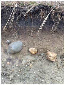
- Glacial Moraines. If you step off the trail near the Erica Lee Knowles cross and look back at the bank, you will see a dirt bank which is being eroded by high waves. You will also see rounded rocks on the bank face. These rocks have been buried here for about 20,000 years. This chaotic mixture of soil, sand, gravel and rocks is called till. The distinguishing characteristic of till is that the material is unsorted. The sorting process is done by water and is ongoing. If you look behind you towards the water you will see rocks, gravel and sand. In storms, the waves come in and erode the bank. The fine grained clay and silt are washed away leaving the rocks, gravel and sand. This bank is part of the Pt. Judith Moraine, mentioned above, which extends down to the Pt. Judith Lighthouse. If you look down in that direction you will see the Scarborough Beach. The beach sand has been sorted out from the clay and rocks. The fine particles of clay can be held in suspension, carried out and settled on the sea floor.
4. Block Island. Block Island is also part of a glacial moraine, but it is interesting because it was deposited in the interlobate zone between the Narragansett Bay-Buzzard’s Bay lobe and the Hudson-Champlain lobe. These two lobes were part of the Wisconsinan Glacier which existed from 75,000 years to about 11,500 years ago. What is really interesting about Block Island is that beneath the moraine from the Wisconsinan glacier are remnants of a moraine from the Illinoian Glacier, which existed from 200,000 to 140,000 years ago. The interglacial period, called the Sangamon peaked about 125,000 years ago with very warm temperatures and sea level about 10 feet higher than it is today, Coral can be found in the sediments of this period at Nantucket and has been dated at about 128,000 years old.
If you take the Malcolm Grant Trail from the main parking lot at Black Point to the cliff above the ocean, you can look across up the bay and see the Beavertail Lighthouse on Jamestown and Newport on Aquidnet Island. If you visit Beavertail out in front of the lighthouse you will see this:
These rocks are totally different from what we see at Black Point and they have been tilted up at an angle. On the north end of Aquidneck Island, the next Island to the right, at the town of Portsmouth, there are coal mines. Coal was also found at Newport. Things are getting curiouser and curiouser. A good source of information on Rhode Island geology is a book, “Roadside Geology of Connecticut and Rhode Island” by James W. Skehan. In the early 1970’s during an energy crisis, Professor Skehan led a group of geologist to look for coal on Jamestown. They did not find coal, but they did find fossilized trilobites about 505 million years old. One species of the trilobites, also found in Newfoundland and New Bruswick, is also found in Europe. So what are these clues- tilted rocks, coal and trilobites evidence of? The answer is Plate Tectonics, a well accepted theory that the continents sit on plates that move over time. The coal was formed in coastal tropical peat beds about 300 million years ago, so Rhode Island was down around the equator at that time. Over 300 million years ago, two continents, Gondwana and Laurentia, along with mircrocontinent Meguma began to come together to form a supercontinent called Pangea. This coming together was more of a slow motion collision, which lasted about 50 million years and resulted in the formation of the Appalachian Mountains and the tilting of the rocks on Beavertail, among a great number of other things. About 200 million years ago the supercontinent Pangea began to break up, forming the continents of North America and Europe and that explains why the 500 million year old fossil trilobites are found on both continents. The North American and European plates are still moving apart to this day at the rate of about an inch a year. The mid-Atlantic ridge is the boundary of the two plates and as they move apart, magma flows up and has formed the longest mountain range in the world, from north of Iceland to southwest of the tip of Africa. The mid-Atlantic ridge is above water in Iceland, as shown below where you can see the split between the North American plate and the European plate.
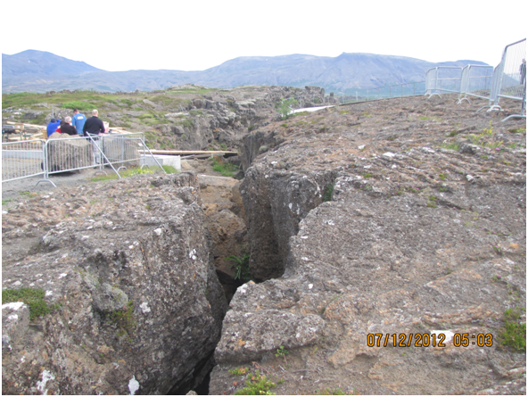
Just look at the crack that separates the North American plate from the European Plate. 200 million years ago, that same crack, many miles south, went through Rhode Island! The book, Roadside Geology of Connecticut and Rhode Island does not get into Little Compton. My guess is that area and east are coastal plains composed of material from glaciers and erosion. If the split in the plates went through Rhode Island, any rock formations east of the split ended up in Europe. I’ll have to get the roadside geology book for Massachusetts to find out.
Wikipedia said that at the Mid-Atlantic Ridge, the plates were separating at the rate of 1 inch per year. Now the motto of the Royal Society of Science in London is “On the word of no one” so you can check it out. Look up the distance from Boston to London in miles; convert that to feet and then inches. Divide that by 200,000,000 years. What do you get?
It was mentioned earlier that the bedrock at Black Point was igneous granite, while at Beavertail there was tilted metamorphic. Plate tectonics was the reason for that. There is a now dormant lateral fault line , the Beaverhead Fault, that goes up Narragansett Bay. It was a right-moving fault, meaning that if you stood on one side, the land on the other side moved to the right. So Pt. Judith moved to the north relative to Beavertail.
Geology is all around us, especially in Rhode Island where there is so much variety in a small state.
For a time-line of geological events that affected Rhode Island, please check the Geology Time Line page.